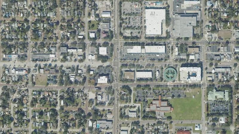
1.06-acre property near St. Petersburg, Pinellas County
451 34th St N, St. Petersburg, FL 33713 · Parcel 16 31 23 00000 220 0400
County roll Jan 1, 2026 · Map data Oct 27, 2026
At a glance
- BuildZoning CCS-2: rules not on file · 3 buildings already on the lot
- GroundNo FEMA flood zone or wetlands mapped · public sewer
- AccessFronts a public road · 329 ft of frontage on 33rd St N
- NearbyVacant land in St Petersburg, all sizes: $1.19M an acre median, 5 sales
- Building24,643 sq ft · built 1960Floor area of all buildings on the parcel
- Acres1.06
- Land typeBuilding on the rollFlorida use code 039
- ZoningCCS-2Corridor commercial suburban
- Future land usePR-CPlanned Redevelopment commercial
- Flood zoneXMinimal flood hazard
- WetlandsNone mappedNational Wetlands Inventory
Land facts
From public records and official maps, each with its source and date.
- City limitsInside the City of St. Petersburg: city zoning and permits applySt. Petersburg zoning map · Oct 2026
- Section, township, rangeSection 23, Township 31 South, Range 16 East, Tallahassee MeridianPinellas County parcel number · 2026 roll
- Impact feesSet by St. Petersburg fee schedule · Jun 2026
- SewerConnected (City of St. Petersburg)FL DOH Water Management Inventory (2016)
- WaterPublic (City of St. Petersburg)FL DOH Water Management Inventory (2016)
- SoilsUrban land, 0 to 2 percent slopesUSDA soil survey (SSURGO) · Oct 2026
- Ground elevationAbout 43–44 ft above sea level; average slope 0.6% (flat)USGS 3DEP 1/3 arc-second (about 10 m), NAVD88; about ±1–2 ft · Oct 2026
- HighwaysSR 595 is 125 ft away and I-275 exit 23B is 1.1 mi away, in a straight lineOpenStreetMap roads · Oct 2026
- Evacuation and surgeNot in an evacuation zone or a storm surge zoneFDEM Know Your Zone evacuation zones · Sep 2026; FDEM storm surge zones (SRES) · May 2022
- Design wind speed145 mph; wind-borne debris regionNIST WindMaps ASCE 7-22 Risk Category II (FBC 2023) via Palm Beach County GIS · Dec 2023
- Red flagsContamination site nearby: an environmental review before you buy is worth itGroundwork check of FEMA, USFWS, FWC, FL DEP and EPA layers · Sep 2026
- Opportunity ZoneIn an Opportunity ZoneU.S. Treasury CDFI Fund · 2018 zones · 2010 tracts · tract 12103021900
- Just value per acre$3.02M an acreJust value $3.2M over 1.06 acres · 2026 roll
Legal description and record
- Parcel number163123000002200400Pinellas County Property Appraiser's record number
- Legal descriptionPART OF NW 1/4 OF SECFlorida DOR tax roll · 2026 roll
- Lot dimensionsSides 330, 259, 215 and 181 ftCounty parcel map outline · Oct 2026
Services and surroundings
What serves the area around this parcel, from federal and state maps. Area facts, not a survey of the lot.
- Electric service areaLikely Duke Energy Florida, LLCAn approximate map: confirm with the utility. Federal HIFLD map, 2025 copy.
- Public land nearbySeminole Park, 0.3 miCity land, open to the public. 51 acres. Being nearby does not give access or hunting rights. USGS protected areas map (PAD-US 4.1).
School district
Public federal records, each with its source and date.
- School districtPinellas County School DistrictGrades pre-K–12 · NCES EDGE school district boundaries, school year 2024–25 (Census TIGER 2025 lines), released Mar 2026. A district, not an assigned school
District details at NCES: Pinellas County School District
Free account: this parcel’s sale history
 St. PetersburgLand prices, flood and zoning$160ka lot, median3,656vacant parcels40%in a FEMA flood zone
Road access
- Has road access OpenStreetMap roads
- Road frontage
- 329 ft on 33rd St N
Home facts
Florida Department of Revenue tax roll · 2026
- Building type
- Hotel / motel
- Bedrooms and bathrooms
- Not on Florida's statewide tax roll
- Living area
- 24,643 sq ft total living area
- Year built
- 1960
- Buildings
- 3
Property tax
Florida Department of Revenue tax roll and millage rates (Data Book), as of Nov 2025
- Property tax (2025)
- At least $62,500 Taxable value $3,400,000 on the 2025 roll
How we compute this
Pay or check a bill at the Pinellas County Tax Collector.
Due dates
Hazards
FEMA National Risk Index for this census tract, not this parcel. As of Dec 2025.
- Hurricane
- Relatively high
- Lightning
- Relatively high
- Tornado
- Relatively moderate
- Heat wave
- Relatively low
- Strong wind
- Very low
- Earthquake
- Very low
- Coastal flooding
- No rating No expected annual loss computed for this tract
- Landslide
- No rating No expected annual loss computed for this tract
How we compute this
Recorded flood claims
OpenFEMA NFIP Redacted Claims v3, as of Sep 2026
- Claims since 1978
- 15 Insured buildings in this census block group
- Outside the mapped flood zone
- Almost all Rated zone X, B or C
How we compute this
Value history
| Year | Land | Improvements | Just value | Change |
|---|---|---|---|---|
| 2026 (preliminary) | $2,703,378 | $496,622 | $3,200,000 | -5.9% |
| 2025 | $1,469,618 | $1,930,382 | $3,400,000 | No change |
Roll values set for property tax · Florida Department of Revenue tax roll (NAL) · 2026
Vacant land prices nearby
$1.19M per acre
Median of 5 sales of vacant land in St Petersburg, all sizes, Mar 2024–Nov 2025
Sales area: St Petersburg
| Land type | Median | Middle half |
|---|---|---|
| Vacant land in St Petersburg, all sizes | $1.19M/ac | $633k–$8.29M |
Nearby
- site plan: ARCHITECTURAL WOODWORKING (COM)Development, approved2.2 mi
- site plan: HAMILTON, ROGER SITE (RES)Development, approved2.2 mi
- site plan: 37TH STREET TRIPLEX'S (RES)Development, approved2.3 mi
- Development, approved2.3 mi
site plan: COMMUNITY RESIDENCE HOME FOR BOLEY, INC.…
site plan: COMMUNITY RESIDENCE HOME FOR BOLEY, INC. (RES)
- site plan: CARIBBEAN COURT APARTMENTS (RES)Development, approved2.3 mi
Neighborhood (Census)
Census ACS 2020–2024 5-year, as of Jan 2026
- Median household income
- $100,250 ± $27,180
- Median home value (owner-reported)
- $584,100 ± $93,303
- Median rent (gross)
- $1,917 ± $346
- Homes lived in by their owners
- 33% ± 10 pts
- Median year homes were built
- 1976 ± 22 yr
- Average commute (one way)
- 24 min ± 11 min · census tract (not published for block groups)
- Population
- 1,558 ± 700
Figures for the census block group around this parcel (a few hundred homes), not this property. This product uses Census Bureau data but is not endorsed or certified by the Census Bureau.
How we compute this
Nearby homes
- 475 34th St NHome, 0.82 acresunder 0.1 mi
- 3311 5th Ave NHome, 0.22 acresunder 0.1 mi
- 3325 5th Ave NHome, 0.17 acresunder 0.1 mi
- 3331 5th Ave NHome, 0.17 acresunder 0.1 mi
- 3250 5th Ave NHome, 0.8 acresunder 0.1 mi
- 3245 5th Ave NHome, 0.34 acresunder 0.1 mi
About these numbersSources, dates and how the estimates are tested
1.06-acre improved parcel in St. Petersburg, Pinellas County: zoned CCS-2, FEMA zone X, no mapped wetlands; vacant land in St Petersburg, all sizes, sold for a median of $1.2M per acre (5 sales, Mar 2024–Nov 2025). Map data as of Oct 27, 2026.
Land prices
Latest arm's-length sale per vacant parcel (parcels of ¾ acre or more, priced per acre), last three years.
Sources
Record
Parcel: 16 31 23 00000 220 0400
Coordinates: 27.7769° N, 82.6784° W
Estimates for your own analysis, not an appraisal or a broker price opinion.
Owners
Your land? Ask us to hide your name: confidential records right away, other requests within five business days.